This page is outdated and just kept for history.
The purpose of task NA-D 3.6 of the SYNTHESYS project is to facilitate the geographical analysis of the networked specimen information.
With networked specimen information we mean specimens that are connected to the GBIF or BioCASe networks. Actually, there
are 76.734.633 specimen or observation records connected to these
networks through 141 data providers [GBIF stats].
The kind of geographical analysis we are considering is distribution modeling, richness analysis, etc. that make use of georeference specimen information available
through GBIF-like networks.
The task started officially on 1 September 2005 at the MNCN in Madrid and will continue for 10 months at least. After this period, the work will possibly be carried on in the European project EDIT.
As part of the deliverable 3.6.2 we have pubslihed the Synthesys Data Publisher. Basically this is a web service for mapping unit level data through a OGC Web Service. The interface specification for this service is already available.The service is temporarily installed on a development server contributed by IPGRI but it will be soon transfered to the computer center at the CSIC-Madrid.
The first deliverable of task NA-D 3.6. has been submitted. This is a report on existing GIS software and standards. During the last three months we have been reviewing the alternatives available for geographical analysis and the decision was made about what to implement.
Sumarizing: We will set up a PostGIS database with deegree in front serving WFS and WMS. For displaying data, we will configure igeoportal and probably mapbuilder. We will also provide interfaces to the WMS and WFS services through Google Maps.
You can download it from our download section or directly from here: Report on existing GIS software and standards.
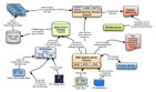 We had been busy preparing documents last week. The meeting in Bonn with Patricia Mergen and Jens Fitzke was really fruitful. We discussed the different projects
we are involved in, SYNTHESYS and GBIF.DE, and how they complement
each other. After drawing a lot on the blackboard we decided to present the results of the meeting in a diagram with the different parts of the architecture
related to the project which is take care of it. The idea is to present this diagram to other projects related to georeferenciation and GIS use of specimen data in the GBIF community. Would be great if we avoid duplication of efforts.
We had been busy preparing documents last week. The meeting in Bonn with Patricia Mergen and Jens Fitzke was really fruitful. We discussed the different projects
we are involved in, SYNTHESYS and GBIF.DE, and how they complement
each other. After drawing a lot on the blackboard we decided to present the results of the meeting in a diagram with the different parts of the architecture
related to the project which is take care of it. The idea is to present this diagram to other projects related to georeferenciation and GIS use of specimen data in the GBIF community. Would be great if we avoid duplication of efforts.
You can find a first second draft of the document in the Proposed architecture section of this page. The document may not be perfect but we hope to use it as a starting point for discussions with other projects and people. By the way, this is the document that I will present next week in the User Interface meeting of SYNTHESYS.
The document is available also in the download section in PDF, PowerPoint, PNG and finally OmniGraffle format, a great tool I've found to create diagrams.