This page is outdated and just kept for history.
 Several projects are dealing with
georeferenced specimen data under the BioCASE umbrella.
Several projects are dealing with
georeferenced specimen data under the BioCASE umbrella.
Core GIS services
The SYNTHESYS project, Networking Activity D 3.6, is aiming at providing GIS infrastructure to facilitate the geographical analysis of georeferenced specimen data. The main work is related to setting up
several OGC services, WMS, WFS, WTS, in front of an index database spatial capable. Other projects will make use of this infrastructure to implement different services or user interfaces.
Itineraries
Part of the specimen data in the GBIF network was gathered in expeditions. Unfortunately, most of the data about the itineraries
of these expeditions is lost or has not been recorded digitally. One
task in Networking Activity D is aiming at reconstructing this itinerary information and make
it available for data cleaning or visualization.
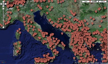
Georeferencing
Approximately 20% of specimen data has exact georeferenciation
by Latitude and Longitude. To do geographical analysis and to improve the quality of the data,
there are several projects helping data providers to georeference their data.