Synthesys Data Processing Service
Overview
This service allows you to process georeferenced data in XML to make it available through OGC services and some other formats. Basically it is a service for portals to help them when making their data available for GIS users; they send the data that they want to make available and the DPS (Data Processing Service) transform it into different GIS formats and make them avaialble for download temporarily.
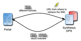 The portal send the data to the service
- The service process it and store it in a temporary database
- The service return a document with information on how to retrieved the processed data (a map, KML, Shapefile, etc)
- The portal uses this document to create links on their website or directly present a map.
More info on the You can find a PDF with a more detailed diagram on the Synthesys Data Processing Service workflow.
Web service URL: http://gis.grinfo.net/DataProcessingService/dps.php
Request
Here is a list of parameters that the service accept as GET or POST.
| Name | Description |
|---|---|
| dataFormat (mandatory) | Format of the document that will be processed and that is sent through the xml parameter directly or pointed to through the doc_url. There are two supported formats right now: simple_xml and gbif_gis. Click on the name for an example on how the document looks like. The gbif_gis format is the output format of a web service provided by GBIF. |
| resultSummaryFormat | The DPS can return to the user a summary of the processing in two different formats: xml and html. The default format is html if not specified. The xml can be used in AJAX solutions to present automatically to the user links to the different processed documents. |
| doc_url | The url of the document that must be processed. Please provide the url urlencoded! |
| xml | Instead of providing a url the data can directly be posted using the xml parameter. |
Example:
Response
The response format is specified using the resultSummaryFormat parameter. Actually two formats are supported xml and html.
The hml format is created for simple integration into portals. The portal can do the request to the service using AJAX and then paste the html results into the page using innerHTML, for example.
The xml format allows better control by the portal. The result document can be parsed and included into the portal the way they want.
If the DSP service finds an error while getting the xml to be processed or while parsing it, it will return a document like if there were no records found to be proccessed (that might change soon and rise a proper error):
In XML for example:
<DataSetReport>
	<datasetId/>
	<featureCount>0</featureCount>
	<OWSurl>http://hq6.grinfo.net:8080/geov2/</OWSurl>
</DataSetReport>
Access methods
Example of use
Sorry, still to do.
Example interface:http://gis.grinfo.net/gbif_gis_bridge/
Technical details
This is a REST service programmed in PHP. It uses PostgreSQL with PostGIS extensions to store the data in temporary tables. After inserting the data on the database it register a new FeatureType in a Geoserver installation. Once the FeatureType is registered in Geoserver it becomes available on all the different OGC standards and output formats Geoserver supports: WMS, WFS, KML, Shapefile, PDF, etc.
There is in the database a table where the temporary datasets are registered for administration purposes: deletion, statistic, etc.
In the same server we have set up some caching mechanism to speed up things, specially a WMS cache because of the expensive performance cost of producing maps on the fly. These caching mechanism are still not active but will be soon.
Access to source code:
Access to the code is granted under the Mozilla Public License. All code is available through the BioCASe subversion repository.
http://ww2.biocase.org/svn/synthesys/trunk/gis/DataProcessingService/